Discover Iceland’s most interesting facts about its volcanoes. This blog is going to take you on a journey through the basics of geology and most significant volcanic eruptions in Iceland. You’ll also find here some useful information about the ongoing Fagradalsfjall eruption, so roll up your sleeves and let’s get to it!
Why is Iceland a volcanic island?
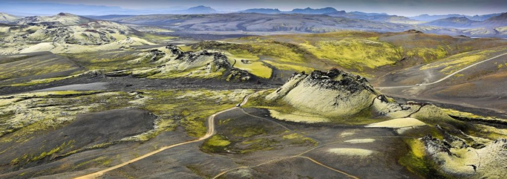
Iceland’s existence is a result of two tectonic plates drifting apart. It is also believed that Iceland sits above a hotspot called Icelandic plume, which supposedly contributed to Iceland’s origin. The hotspot itself is an outcome of both Eurasian and North-Atlantic plates diverging. Formed about 18 million years ago, Iceland is one of the youngest landmasses on the planet! As the plates move away from each other roughly 2.5cm every year, the magma from the mantle rises. It results in volcanic eruptions that are not rare occurrence in Iceland. It happens along the whole rift and it can be also seen on island such as the Azores and St. Helena.
Iceland’s the perfect place to see such geological and volcanic activity. There are a few places in the country where it’s possible to literally walk between the continents. Such places include the so called The Bridge Between Continents located on the Reykjanes Peninsula and Þingvellir National Park, which is the only UNESCO World Heritage site on the Icelandic mainland.
Iceland’s truly the land of ice and fire that never sleeps. It constantly expands, it’s being shaken with tremors and it’s geothermally active. It’s truly an extremely interesting place, where people are used to live around such unusual events. It’s absolutely ordinary to see houses built into lava fields or surrounded by basalt columns. Even though Icelanders are used to it, it doesn’t mean they’re indifferent! The Fagradalsfjall eruption has quickly became a national place of interest, where paths and parkings had to be quickly arranged. At the same time, the geological activity provides endless supplies for the geothermal energy. Most of the homes in Iceland are heated with geothermal water coming from how springs which can be found across all the country. Thanks to these natural resource Iceland’s happens to be one of the most eco-friendly countries all around the world. Let’s dive slightly deeper into the most significant eruptions in Iceland!
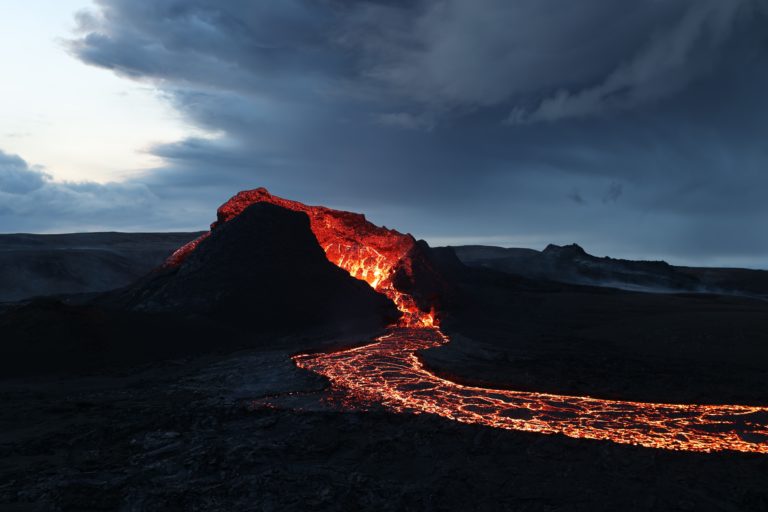
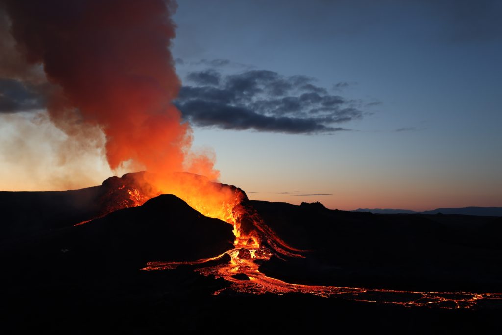
Fagradalsfjall eruption – currently ongoing
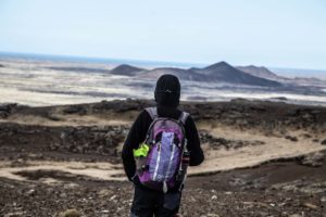
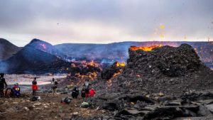
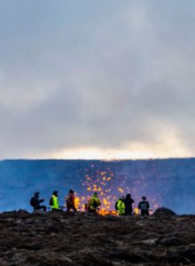
The current ongoing volcanic eruption in Iceland is located on the Reykjanes Peninsula, en route between Keflavik International Airport and Reykjavik. The area was seismically active since the late February 2021, being shaken everyday for a few weeks. Everyone was expecting the same and when the fissure finally opened up on March 19th, the national excitement was unreal. The first people who got to see it with their very own eyes, were the one who booked helicopter tours in advance. Due to high level of interest in visiting the eruption site, the appropriate services had to take quick actions. Soon the hiking paths and parking lots have been set as well as informative websites and maps.
At first there were only two hiking paths available, A and B. Both of them were rather on the challenging side, although path A was definitely hiked more often. They provided a view over the eruption from two different perspectives. The services quickly arranged the whole area to be easily accessible and fun to experience. However, the site constantly changes so please monitor it accordingly to your travel plans. Most of the information about the current activity and the accessibility can be found on safetravel.is website that we highly recommend to be familiar with before you plan your hike.
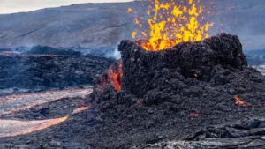
Fagradalsfjall is a shield volcano, which means they’re vast, broad with shallowly-sloping sides resembling a warrior’s shield. Even though it might not look like, they’re still dangerous. Many tourists have been seen walking on the surface that looks like solid lava. You always have to assume that under the outer crust is only the first layer that cools down quicker – there’s flowing boiling lava underneath it! We know it’s super exciting to see new earth forming, but please be responsible. The service workers already have a lot of work to do! If you’d like to read more about the eruption and get some practical information, we’ve already got it covered on our blog page 🙂
Eyjafjallajökull – 2010
Of course – Eyjafjallajökull! The tongue-twisting name of a volcano that caused many disruptions around Europe in 2010. Some say that it was the reason of a tourist boom in the following years, which helped Icelandic economy after the 2008 market crash. It’s located in the South of the island and the caldera is covered by an ice cap.
Although it wasn’t a big volcanic eruption, it caused a lot of trouble in air traffic across western and northern Europe for about a week. It actually erupted three times – in March, April and May. In April it also caused at occurrence known as jökulhlaup, Thant can be translated as meltwater flood. It rushed down the nearby rivers and 800 people had to be quickly evacuated. By the end of May the eruption was announced to have stopped, but the scientist continued to keep and eye on it.
For the past 11 years the volcano has been dormant and it’s nothing but a place of interest now. If you’d like to find out about it, you might want to visit the Eruption Visitor Centre in Hvolsvöllur, located close to the famous waterfall Seljalandsfoss and Skógafoss along the South Coast. If you’d like to explore it even more, make sure to contact us so we can arrange a glacier hike for you!

Laki 1783-1784
It’s the most significant and the most deadly volcanic eruption that has ever happened in Iceland. The Laki Craters known in Icelandic as Lakagígar is a 27km long fissure consisting of 130 huge craters located on the southwest side of Vatnajökull. The eruption itself lasted 8 months and it was simply catastrophic. It was divided between explosive (shorter ones) and lava-producing phases (longer ones).
It resulted in so called Haze Famine, the worst environmental disaster in Iceland. The haze gradually expanded, finally to be covering a quarter of the Earth surface, reaching all the way to Russia and China. The toxic had a tragic influence on farm animals, which became intoxicated. The same happened to farm crops, which became completely inedible both by humans and livestock. The haze cut off the sunlight, Iceland became even colder and the sea ice reached the coast. Only 25% of the farm animals was saved and one in five Icelanders lost their life due to hunger.
Volcanoes are often connected with the danger of being burnt or losing life to lava floods, meanwhile the long-term results seem to be much more deadly. Iceland has got evacuations systems prepared and ready to be used. The scientists also constantly monitor the seismic activity, making sure to find out anything as soon as possible to keep the country safe.
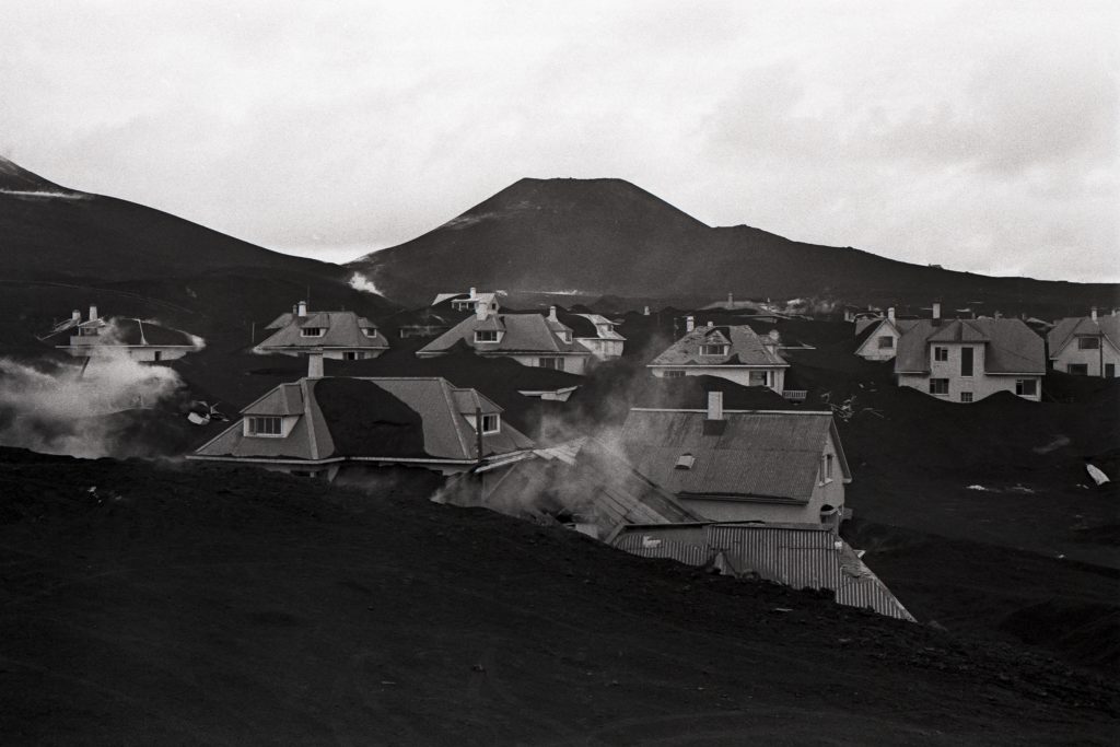
Eldfell in Westman Islands – 1973
Westman Islands, in Icelandic called Vestmannaeyjar, is an archipelago located by the South Coast. Heimaey happens to be the only inhabited island among them all and it’s simply stunning. It’s also home to a volcano that until 1973 it was believed to be extinct as it had’t been active for over 5.000 years. It erupted without any former warning and the whole town had to be quickly evacuated to the mainland. Thankfully no one died except one person, although nearly 400 homes were demolished.
Heimaey is known for its harbor and the fishing business, so once the people got evacuated, the rescue workers wanted to change the lava flow to protect the harbor. They used sea water! By pumping it constantly on the lava flow, they managed to redirect it from many houses. They prevented it from closing the harbor, which would have been disastrous for Iceland’s economy.
Nowadays, Heimaey is back to normal. It’s thriving and offers many opportunities for travelers. It’s stunning with its rock formations, breathtaking harbor, puffing lookout, Beluga Whale Sanctuary and boat tours. You can hike the Eldfell volcano and see the stunning island from above. If you dig Deep enough in the ground, you can still feel the warmth from cooling lava. How COOL is that?!
Other significant eruptions
- Grímsvötn (2011) – Grímsvötn is located under the largest ice cap in Europe – under the Vatnajökull glacier. Its most significant eruptions happened in 1783, 1873 and 1902. The 2011 one happened on May 21st, after a large spike in tremors has been detected. It quickly broke through the ice and started to spew volcanic ash in the air. Glacial flooding was expected but it never happened. The eruption itself lasted a week and caused trouble to the aviations system. The town of Kirkjubaejarklaustur has been the most affected and cleanup actions have been organized. Lots of the households has the opportunity to take advantage of their fire insurance. Some sources say that mortality in Sweden has been increased during the eruption, although it wasn’t that significant.
- Bárðarbunga (2014-2015) – a Hawaiian type of eruption that started in August 2014 and lasted for half a year. It released large amounts of sulfur dioxide, causing a significant drop of air quality in Iceland. The volcano’s also covered by the Vatnajökull ice cap and it’s a part of an extensive volcanic system. It hasn’t produced a lot of ash, therefore aviation system remained undisturbed. In 2015 the area has been opened for visitors, and it’s available ever since.
- Hekla – one of the most active volcanoes in Iceland, which has erupted over 20 times since 874. It’s a stratovolcano that rises 1,491 meters above the sea level. It’s a part of volcanic ridge that’s 40km long. In the past, it was often referred to as the gateway to hell. The Hekla eruptions are pretty tricky to predict. Some are very short, and some last for up to 6 years. But there’s definitely one rule to keep in mind: the longer Hekla sleeps, the most catastrophic the eruption. The last one took place in 2000.
- Katla – the star of the newest Icelandic series available of Netflix. It’s a large volcano located in the Southern part of Iceland that’s famous for its frequent eruptions. Twenty eruptions have been noted between the years 930 and 1918 with breaks of 20-90 years in between. It hasn’t erupted in 103 years, so who knows – maybe it’s slowly getting ready to show its full potential? The name Katla is also used as a female first name.

All of the volcanoes in Iceland are constantly monitored. The scientists work to prevent any catastrophes, so the Iceland residents sleep undisturbed at night. If you’d like to dig a little deeper and find out more about the ongoing volcanic eruptions in Iceland, we highly recommend giving @geology_with_helga a follow on Instagram! If you’re interested in hiking any of the sites mentioned, please don’t hesitate to give as a call or write us an email 😊