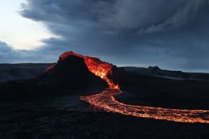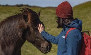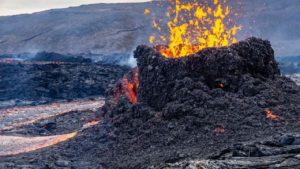
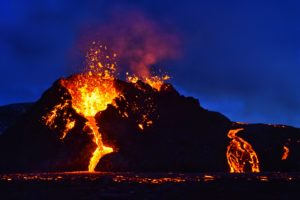
One of the main characteristics of Iceland is its unpredictable nature. Which is why so many of us adventurers are so passionate about this land. On March 19th 2021, after weeks of powerful earthquake swarms shaking Southeast Iceland, nature gifted us with a very special event that would soon become a very popular attraction, as a volcanic eruption finally occurred on the Reykjanes peninsula, in the Geldingadalir valley next to the Fagradalsfjall mountain. This small effusive eruption happens to be located in a pretty easily accessible area and has attracted a quarter of the population of Iceland within a month, according to a poll conducted by Fréttablaðið.
As more and more visitors headed to the volcano, the authorities chose to make the area more accessible to ensure that the hike to the eruption site remains as safe as possible to everyone. Two trails then got marked and the closest road, Suðurstrandarvegur, got reopened to the public after being closed to everyone except the rescue teams and scientific teams during the first few days of eruption. But despite those measures, the unpredictability of nature is very well at work in Fagradalsfjall, given the volcanic eruption itself and also the fact that the Reykjanes peninsula is formed with desert-like landscapes, lava fields and mountains, which makes hiking there quite challenging.
A quarter of the population of Iceland reportedly visited the eruption site since its creation.
A challenging hike that has been facilitated during the first few weeks of the eruption
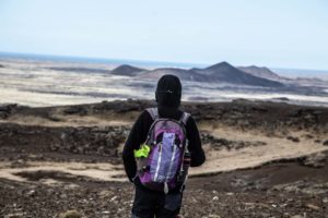
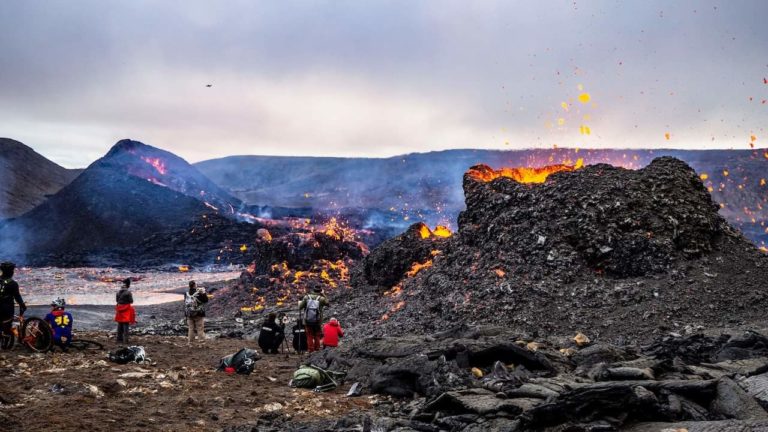
The hike starts from the route 427 (called Suðurstrandarvegur), at a 10 minutes drive east from the closest town in the area, Grindavik. When the eruption started, Suðurstrandarvegur was closed for a few days and the first hikers who headed to the volcano had to start their journey many kilometers further, from the Blue Lagoon area, making it a 7-8 hour long hike to get there and come back – the decision has been made in the meantime to open Suðurstrandarvegur and reduce the hiking length by a few hours. Two hiking trails then got marked to prevent hikers to get lost on their way to the site. Parking lots are now located right next to the hiking trails’ entrance as well as by the road, a few hundreds meters away from the trails’ entrance. Those trails (trail A that ends on the eastern side of the eruption site, and trail B which ends on the western side) are pretty much the same length, around 3 to 4 kilometers ; both include climbing a steep slope with a 250 elevation gain on less than a kilometer and on a rocky terrain that makes it quite challenging as it can be easy for visitors to slip on rocks and mud. The first 2 kilometers from the parking lot are pretty easy to walk, as they consist in walking on a flat terrain and gravels that have been put on the trail by the authorities to make it easier to hike on. Therefore, what makes the trail difficult for hikers is that last part all the way to the top of the hill; at first, a rope has been put on both trails to make the very last steeper part easier to climb. It is to note though that trail A got recently modified due to big changes on the eruption site, and doesn’t include any rope anymore. The eruption site itself is as challenging to move through as the hike to get there: the eruption site is to this day located in the Geldingadalir valley that has been entirely filled with lava, and on the hill next to it, which means that if you want to admire the different eruption vents, you have to bypass the lava fields on the hills next to them. Those hills are, like the ones where the two hiking trails are located, covered with moss and rocks, an uneven terrain that require for hikers to be very careful of where they step foot to make sure they won’t slip.
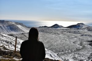
View on Suðurstrandarvegur from the hiking trail B (at the top of the steep slope).
Planning and bringing the adequate equipment are primordial
These challenging conditions make it necessary to plan your hike and bring the appropriate equipment to ensure that your journey to the volcano is as safe and comfortable as possible; starting with footwear – good hiking shoes are vital on such a challenging terrain, with a great grip that would prevent slipping on mud or unstable rock chunks, and completed with traction devices for winter conditions such as snow or ice. If you’re not used to difficult hiking conditions, hiking poles might also help a lot to climb up the hills. As the Icelandic weather changes pretty quickly, make sure you wear proper clothes to protect yourself from the windy and rainy weather. The hike to the volcano takes from 1h30 to 4 hours depending on your hiking skills level, and most visitors stay on the site a few hours to admire the lava flows and craters spitting fire – it makes the whole trip to the volcano quite long. Make sure you bring enough water (at least 2 liters) and food, as difficult hiking conditions make us spend more energy. The trails are very well marked but getting lost on the way to or around the eruption site cannot be excluded and the phone connection is very poor in this area making it difficult to use a phone GPS, so it is advised to bring a map of the area, a GPS and/or a compass, as well as a power bank in case of needing your phone to call for help. If you plan on watching the eruption by night, a headlamp and extra batteries will make your journey to and/or back from the eruption site way easier.
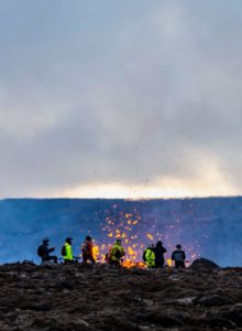
Many hikers stay on the eruption site many hours to have the opportunity to see the volcano by night.
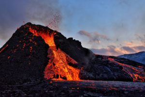
The eruption site itself displays many risks and safety rules must be followed
Another danger that needs to be taken into consideration is the gas pollution, which comes from the blue smoke clouds coming from the craters and from the lava flow but is also not visible and cannot be detected by scent. It is quite common that one or both hiking trails are being closed if the weather and gas pollution make the area too dangerous for visitors. It is necessary to get information on gas pollution as well as the weather forecast, either by asking the rescue teams once arriving on site or at the entrance of the hiking trails, or by visiting information websites such as safetravels.is that is updated every day. If you feel any discomfort to breathe or any other symptom (headache, nausea, etc), it is primordial to leave the area immediately, as gas poisoning can be very serious. It is strongly advised to keep children and dogs away from the area, as the gas and fluorine could be life-threatening for them. The area has changed dramatically during this first month of eruption with the opening of many new eruption vents a few hundred meters away from the original two craters. An area – including the end of the original trail A – has been defined around the different fissures and craters and is considered as immediate danger and forbidden to step foot on. For everyone’s safety, yours and the rescue team’s members, please do not walk in this area, there are many other spots where you can admire the show that the Fagradalsfjall volcano has to offer.
Safetravels.is regularly updates the hiking trails’ map, as the lava flows and new fissures might put visitors at risk even on the trails themselves. Make sure you check out the website before your visit.
What should always be kept in mind while you’re on the eruption site is that volcanoes are unpredictable and a new fissure might open at any minute. Also, the lava flows grows fast and can change directions with very short notice. By the time this article was written (mid-April), it started flooding the end of the new trail A. It is advised to always stay at a safe distance of the lava flow (at least a few dozens meters) and above it – lava flowing down a hill is way faster and it could be easily catching up someone who would be located under it. The area is closed during the night, which means that it is still accessible as the trails are not physically closed, but that rescue teams are not available in case of emergency or if an accident occurs.
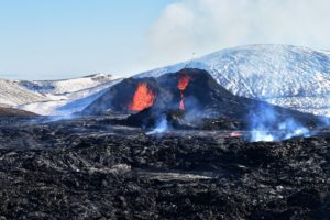
Visitors face many dangers and difficulties on site, such as gas pollution (here you can see the blue smoke coming from the lava field, but gas is also invisible, odorless and tasteless) and a challenging terrain sometimes combined with challenging weather conditions.
A once-in-a-lifetime hike nonetheless
The eruption site is therefore accessible to everyone, and many non experienced hikers made it there without any complication. It is necessary though to bring the adequate equipment and to hike at the pace that is the most comfortable for you – do not hesitate to take your time and take breaks on the way. It is important to keep in mind that safety measures should be followed, in order to keep yourself safe but also to not put the rescue teams at risk more than they already are, as they are exposed to the unpredictable nature of a volcanic eruption. The main rule on this hike is to plan it, by checking the most recent safety advices and the weather forecast, and by bringing equipment according to those information. This trip might be quite challenging for a novice hiker, especially if you’re not used to steep slopes, but the exceptional breathtaking views on the volcano once you’re on the site make it absolutely worth it. It is a once-in-a-lifetime hike that I would highly recommend.